 )
)
)
)
When we acquired the Purola Preserve tract in 1976 we were told that Deadman's Creek, which runs across its valley was a permanent all–weather creek. And this held valid until the prolonged drought of 2006, when portions of the creek without major springs ceased to flow. During the 2006 drought most springs continuued to flow, but their output only sufficed to maintain pools of water in their immediate vicinity. The rains returned at the end of 2006, and the abundant rainfall of 2007 recharged the area's springs, tanks, acquifers. But the drought resumed with a vengeance in 2008, continuing without letup into 2009. By mid summer 2009 the creek and all springs were dry — the first time in known history. Our well went dry. Old timers in the area say that the current 2009 drought is worse than that of the 1950s, frequently cited as the worst drought in Central Texas. And, of course, temperatures near or above 100° F for much of the summers of 2008 & 2009 have meant that our meager rains have had virtually no long-term impact.
Without the reprieve of 2007, the current drought would have been devastating.
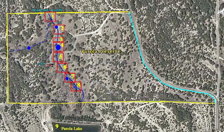
Once I realized the historic nature of the drought I began to document its severity and its 'progress.' These pages present the history of Deadman's Creek on Purola Preserve since the mid 1970s at 8 points, plus the large tank above the preserve, now known as Purola Lake (cf. Google Earth). These points serve as benchmarks for the status of the creek.